The 2016 Kaikōura earthquake caused sudden large-scale changes along the coastline. The intertidal zones were lifted up to 6 metres in some places. In the media, footage of the uplifted coastline and exposed pāua beds and kelp forests were used to show the force and extent of the earthquake. Extensive landslides along the coastline resulted in further damage to the marine environments with large amounts of sediment pouring into the sea.
Marine scientists referred to the earthquake as a “sudden, overnight tipping point”, and within 4 days of the earthquake, they were on location at Kaikōura in order to survey the damage.

For marine ecologist Dr Leigh Tait, these events provided an opportunity to investigate how the loss of kelp has modified the marine environment and the potential tipping points affecting kelp-dominated ecosystems. With funding from the Sustainable Seas National Science Challenge, Leigh and scientists from NIWA and the University of Canterbury mapped kelp forest recovery in areas with different levels of uplift.
Why research kelp?
Leigh is interested in kelp for a variety of reasons. New Zealand kelp forests are under pressure from climate change, marine heatwave events and shifting storm dynamics. Pressure from land-based activities that cause sedimentation and eutrophication also impact kelp forests. Sediment in the water affects the amount of light kelp can get in order to photosynthesise.
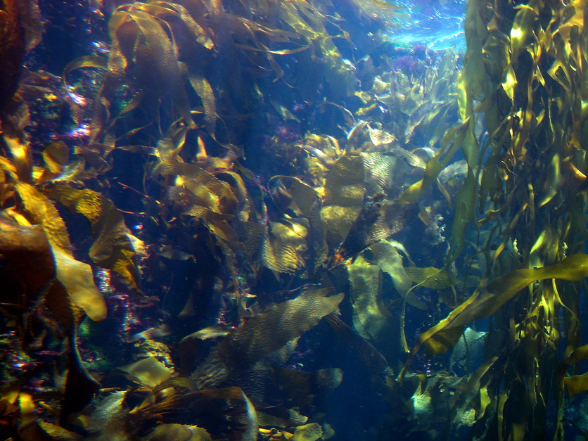
Habitat-forming seaweeds like kelp drive marine biodiversity and can therefore be used as an overall measure of reef health. The research provided an assessment of how recovery of these important habitats is affected by degrees of stress – in this case, the stress being the amount of uplift. The work will continue to help marine managers identify areas that need protection to support kelp recovery.
The wide-scale loss of habitat-forming species provides an important contrast to studies typically done in ecological disturbance experiments at the scale of metres. This disturbance happened across tens of kilometres.
Dr Leigh Tait
Kelp – a key species
New Zealand’s largest seaweeds are commonly referred to as kelps. These include a number of brown seaweed species. Kelp species form forests from the intertidal zone (the region of the shore exposed to the air during part of the day) to the sublittoral zone (the region that is never exposed to the air).
To understand the different zones within the reef, take a look at Life on the reef.

Kelp are a key species within the reef ecosystem and beyond. Kelp forests provide important ecosystem services both within the reef zones and further out to sea:
- Providing a habitat for a number of creatures – for example, many fish species use the kelp as a nursery. These fish then move out to sea where they provide food for other species, including valuable fisheries species.
- Providing food for different creatures – including a variety of fish species and shellfish like pāua.
- Fixing carbon – kelp photosynthesise sunlight and convert carbon dioxide (and water) into food. On a global scale, loss of kelp will reduce the amount of carbon removed from the atmosphere and stored on the seafloor (a process known as carbon sequestration – where carbon from organisms is buried and locked away from disturbance and release), potentially accelerating global warming.
- Buffering the intertidal habitats from wave disturbance – making the environment more hospitable for a wider variety of marine organisms.
- Increasing dissolved oxygen, which can be used by marine flora and fauna.
Using drones to assess environment
The large scale of the area that needed surveying combined with access to many sites being made more difficult by the earthquake meant that Leigh and his team had to innovate in order to be able to collect the data and make the assessments the research required.

Multiband imaging of the Kaikōura coast
Top left, RGB (red-green-blue) image, colours as we see them. Top right, multispectral image, false colour showing infrared light, which we can’t usually see. Bottom left, combined RGB and multispectral showing infrared enhanced colours. Bottom right, classified imagery using machine learning. One characteristic of the multispectral camera is that it only captures light from very narrow wavelengths, which means that it must detect very low intensities of light.
To understand the impacts and changes to the Kaikōura coastline, Leigh and his team assessed:
- wide-scale kelp bed survival using drone images
- changes in ecosystem services – for example, oxygen production
- small-scale recovery of kelp species.
The use of drones was a challenging new approach that saw Leigh working with other scientists and technicians in order to optimise the drones specifically for marine research.
Drone data was validated with field surveys using transects at different sites. This survey data was then combined with the broader scale measurements from the drone.
Learn more about Leigh’s use of drones to map the marine environment and the work that had to be undertaken to optimise them for this research in Monitoring marine environments with drones.
Findings
These were some of the key findings from Leigh’s research:
- The threshold of uplift for survival of some key kelp species was 3 metres and below, but others were greatly affected by uplift of less than 1.5 m.
- Changes to the abundance of kelp affected other ecosystem services such as the amount of dissolved oxygen in the water.
- Areas of coast with higher levels of suspended sediments were affected by less uplift than sites with clear water.
- Using multispectral imaging enabled accurate distribution maps to be produced and helped identify areas where important species survived.
The researchers produced a publication comparing RGB (red-green-blue) standard cameras and multispectral cameras for use to record marine environments from a drone.

Leigh is now working with other organisations interested in using the drone technology to map marine areas. He is also working with underwater remotely operated vehicles (ROVs) to optimise their use by biosecurity staff to assess the bottom of boats in ports for plant and animal pests that have hitched a ride from overseas on a boat.
Related content
Read about Ecosystem tipping points and stressors and research being undertaken by the Sustainable Seas National Science Challenge in Investigating marine and coastal tipping points.
Explore Marine habitats and Marine food webs and learn more about the complexity of these in Dynamic seas.
Learn more about the ocean, the carbon cycle and climate change in The ocean and the carbon cycle, Ocean dissolved gases, The ocean, CO2 and climate change – timeline and Carbon dioxide in the ocean.
The citizen science project Floating Forests needs the help of citizen scientists to identify kelp forests from satellite images.
See our Seaweed and algae Pinterest board for more resource ideas.
Sustainable Seas collection
See the range of content that we have developed using resources from the Sustainable Seas National Science Challenge in this handy collection. Learn how to create, use and share collections here.
Useful links
In this recorded webinar from Sustainable Seas National Science Challenge, hear Dr Leigh Tait talking about his research on monitoring kelp and seaweed biodiversity with drones.
For a visual interactive showing different areas mapped by Leigh’s team, the places mapped and different drone images, look at Earthquake impacts to Kaikōura’s rocky shore.
Te Ara has a useful summary of different kelps and seaweeds here.
This article from 2023 in The Conversation covers how new research is demonstrating that New Zealand’s vital kelp forests are in peril from ocean warming – threatening the important species that rely on them.
Acknowledgement
This article has been developed using resources from the Sustainable Seas National Science Challenge and Dr Leigh Tait.
Further funding for this research was provided by the Ministry of Business, Innovation and Employment Endeavour Fund.