Satellites help scientists measure the thickness of land and sea ice in Antarctica. To validate these measurements, Dr Wolfgang Rack from Canterbury University travels to Antarctica each year to physically measure the thickness of land and sea ice.
Once the validation is complete, ice thickness data can be used to model how the Earth’s climate, sea temperature and sea levels may be changing.
CryoSat-2 satellite measures ice thickness
CryoSat-2 orbits between 720 km (perigee) and 732 km (apogee) above the surface of the Earth. It is a 750 kg satellite launched by the European Space Agency (ESA) in April 2010. It is in a polar orbit, which means it can measure ice thickness and coverage in both the Arctic and Antarctic regions. Each orbit takes 99 minutes.
The CryoSat-2 satellite sends out a radar signal that is reflected from the surface of the ice. The time taken for this signal to return allows the height of the ice above sea level to be measured. This height is called the freeboard. The thickness of the sea ice can be calculated using this freeboard measurement and the known density of the ice.
Types of ice
It is important to note that there are two kinds of ice in Antarctica – sea ice and land ice.
Land ice is freshwater ice that covers the land area of Antarctica. The average thickness is nearly 2 km, and at its thickest point, it is nearly 5 km thick. Some calculations show that Antarctica has 70% of the world’s freshwater and 90% of the world’s ice. This ice is called the ice sheet. It has been formed over millions of years. The ice sheet gradually flows towards the sea. The part of this ice sheet that floats on the sea before breaking off is called the ice shelf. Any part of the ice sheet that breaks off and melts contributes to sea level rise.
Sea ice is frozen seawater and is normally only about 2 metres thick. Every winter, Antarctica doubles in area because of an increase in sea ice. When sea ice melts, there is no change in sea level, because this ice was produced from the seawater to begin with. However, sea ice is very important to maintaining the cool temperature of the oceans. Sea ice reflects sunlight away from the ocean so helps to keep it cool. If there was less sea ice, more light would be absorbed by the seawater. This would cause the oceans to heat up more and would slow down the ocean currents that are so important to the world’s climate. The increased temperature of the sea would also cause the ice sheets to melt and break off more quickly.
Measuring the thickness of land ice and sea ice and how quickly these thicknesses change allows scientists to make more accurate predictions about future changes in Antarctica. The study of whether the total amount of ice is increasing or decreasing is called the ice balance.
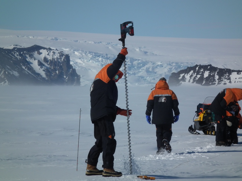
Validating measurements
A large part of Dr Wolfgang Rack’s research is to validate the satellite measurements. This means making sure the satellite data matches up with measurements taken directly.
There are two phases to the validation process:
- Large holes are dug into the ice to measure ice thickness and density. This is a very important but very slow part of the research.
- A helicopter is used with a device called an EM bird (electromagnetic bird). This is a torpedo-shaped object that is suspended beneath the helicopter at a height of 10 m above the ice. The helicopter flies at high speed and can cover thousands of kilometres each year along the path of a satellite. The satellite cannot measure sea ice thickness directly, but the EM bird can. It emits an electromagnetic pulse that travels through the sea ice. When the pulse hits the seawater below, a reflected signal is sent back towards the helicopter.
For future research, Dr Wolfgang Rack hopes to be able to use a plane rather than a helicopter in order to cover a greater distance and to validate even more data. The land area of Antarctica is 14 million square metres – nearly twice the size of Australia. Annual sea ice formation increases this area to over 20 million square kilometres. Analysing any changes to ice thickness and coverage is only possible because of data from satellites.
In 2021, Dr Rack and his team added a snow radar to the EM bird. This provides separate measurements for the thickness of the snow and the ice, allowing more accurate data to be collected. Both systems will be used to underake the most comprehensive study of Antarctic coastal sea ice ever carried out. The survey takes place in late 2024.
Activity idea
Practise matching up satellite images with on-the-ground observations in the simple activity Validating remote sensing observations.
Related content
Monitoring Antarctic sea ice and the role that models play in prediction of ice melt and its consequences is crucial, explore more in this Conversation article.
Useful links
Watch an animation that shows how the Antarctic sea ice increases and decreases during a year.
The CryoSat-2 satellite was launched with the expectation that it would work for at least 3.5 years. This BBC article notes that engineers hope to keep it operational until 2024. This will ensure the continuity of long-term records of changes to sea ice.
This article from Stuff has video of the EM bird, suspended from a helicopter and collecting data.
