Dr Wolfgang Rack from Gateway Antarctica explains how physical and aerial measurements of sea ice are made and then used to validate measurements received from satellites.
Points of interest:
- Wolfgang travels to Antarctica to physically measure the ice. Why do you think he does not rely on satellite measurements alone?
- What does the word ‘validate’ mean?
Transcript
DR WOLFGANG RACK
We are using for our research high-resolution satellite images and radar altimeters, which measure the surface elevation. We use satellites, for example, like EROS 1 and EROS 2, but also now the new CryoSat-2 satellite.
CryoSat-2 is at the moment the only satellite which is solely dedicated for ice research. The satellite is very high so the satellite flies with the ground speed of about 7 kilometres per second. So along this track, we get sea ice thickness measurements which are about 1 kilometre wide along that orbit, and those orbits are separated by several kilometres from one orbit pass to the next. So, we get this information from ice thickness quite quickly. To get a complete picture and a complete ice thickness map, we have to combine all these orbits and we have to mosaic those orbits together.
We need to validate the data because the requirements for accuracy are very demanding. Validation is simply the comparison between the satellite measurement with the measurement in the field. So at the end, we would really like to know what the quality of the satellite measurement is.
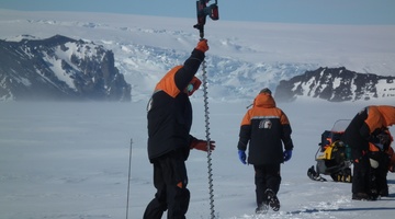
The validation means going to the sea ice and drilling a hole, putting a ruler into this hole and measure directly the sea ice thickness and comparing that measurement from the satellite to the direct measurement of the sea ice. So we are very restricted in doing this because of the logistical constraints because the sea ice is so dynamic.
But we try to extend those measurements by using airborne measurements on the helicopter. On the helicopter, we are using an instrument, which we call EM bird, and the EM stands for electromagnetic induction. We cannot use radar instruments to measure the sea ice thickness because there is still some salt in the sea ice, which effectively absorbs the radar wave. So the EM bird works with a different technology. It’s electromagnetic induction, and this means that this instrument emits a magnetic field, and this magnetic field can trigger a very small electric current in the seawater, and this very small electric current induces a secondary magnetic field, and this is what we measure. And this magnetic field is related to the distance between the instrument and the seawater. So the EM bird is the only remote-sensing instrument which can measure sea ice thickness directly. So it hangs under a helicopter, and it needs to be as close to the surface as possible.
We plan to measure ice thickness in the area of the Ross Sea. At the moment, we are using helicopters which are quite restricted in terms of distance, and in the season, we can fly a few thousand kilometres to measure the ice thickness, but we plan to use an aircraft in the future, which means that we can cover much larger areas and that we can follow longer parts of the satellite track.
Acknowledgements
Cryosat II footage courtesy of European Space Agency/ESA
Daniel Price, University of Canterbury