New Zealand – isolated islands or part of a continent?
New Zealand – the country – has a total land area of 268,000 km2. Zealandia/Te Riu-a-Māui – the proposed continent – has a land area of 4,920,000 km2! This huge area of land is about three-fifths the size of Australia. On the surface, Zealandia does not look like a continent because 94% of it is covered by the Pacific Ocean. But when you look at a bathymetric map of the area and consider some of Zealandia’s features, the proposal for it to be called a continent becomes more convincing.
What makes a continent a continent?
Geologists define a continent as a major land mass, including both dry land and the continental shelves that lie off the coast. A continent is made of continental crust – a base of igneous, metamorphic and sedimentary rocks. (Oceanic crust is made up of basalt and is thinner and denser than continental crust.) A continent should also have areas of high elevation when compared to the surrounding seabed. What isn’t defined is size – there is no minimum size requirement for a continent.
Zealandia meets these definitions. It is a continuous expanse of continental crust, linked together by the islands of New Caledonia to the north, North, South and Stewart Islands (Te Ika-a-Māui, Te Waipounamu and Te Punga o Te Waka a Māui), the Auckland Islands and Campbell Island to the south and the Chatham Islands to the west. Zealandia’s continental crust is physically separate from Australia’s continental crust. Zealandia is also significantly elevated, rising about 3,000 m above the surrounding oceanic crust.
Nature of science
Words that have a meaning in a science context can have different meanings in other contexts. Science identifies continents by their geological attributes. Others identify continents by historical, cultural or political attributes – leading to debates about the number of continents. (This supports the investigating and communicating in science strands and the capability using evidence.)
Putting the pieces together
The unusual underwater geography that surrounds New Zealand has intrigued geologists for more than a century. Information gathered from satellite measurements and from seafloor sediment cores work a bit like puzzle pieces, helping scientists develop clearer pictures of the area.
If we could pull the plug on the world’s oceans, it would be quite clear that Zealandia stands out.
Dr Nick Mortimer, GNS Science
The American geophysicist and oceanographer Bruce Luyendyk introduced the name and the concept of the submerged continent Zealandia in 1995. New Zealand scientists Nick Mortimer and Hamish Campbell advanced the idea with their 2014 book Zealandia: Our Continent Revealed. However, it was their paper Zealandia: Earth’s Hidden Continent that propelled Zealandia onto the world stage. The New Zealand Herald reports that the paper “instantly captured the world’s imagination, generating more than 16,000 news articles that reached nearly a billion people”.
Although it caught people’s attention, Zealandia is not likely to appear on world maps any time soon. There is no group that officially names continents. Internationally, people can’t even agree if there are five or seven continents, so at the moment, agreeing to eight seems unlikely. Dr Mortimer says, “Supporters will have to continue using the term and hope it catches on.”
Pangaea, Gondwana and Zealandia
Scientists have learned a huge amount about plate tectonics and continental drift over recent decades, and it has changed some of our thinking about the world. The general understanding is that all land on Earth was once part of a supercontinent called Pangaea, which later broke up into Laurasia and Gondwana. Gondwana continued to move and separate into the more recognisable land masses we see around us today.
About 85 million years ago, as the seafloor spread, Zealandia broke away from Australia. Initially, Zealandia was all land, but as it moved and was stretched, much of it sank beneath the sea. Then the plate tectonic movements changed direction, and instead of moving away (extending), the plates started to collide. New Zealand began to be pushed up above sea level while most of Zealandia remained submerged.
Updates
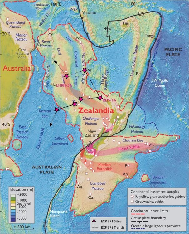
In January 2020 newly published results from expedition #371 explained how two violent tectonic events shaped the Zealandia continent and also why this continent is so different to others. A 2021 paper published in the journal Geology shows that there are billion-year old rocks concealed in the deep crust beneath Fiordland and Rakiura/Stewart Island. Ancient rocks are a feature of all of the other continents. The paper's lead author, Dr Rose Turnbull of GNS Science, concludes that there's now no doubt that Zealandia/Te Riu-a-Māui is a continent.
Nature of science
Those who consider Zealandia to be more than a microcontinent (a fragment of continental crust) are doing what scientists are so well known for – gathering additional evidence and engaging in robust debates – to raise the profile of the submerged continent.
Related content
Read about other JOIDES Resolution expeditions in the articles Voyages of discovery and Aboard JOIDES Resolution expedition #375.
Useful links
One of the purposes of JOIDES Resolution expedition #371 was to explore the long-lost continent of Zealandia. Find out more in this blog and video.
Te Ara – The Encyclopedia of New Zealand has stories about New Zealand’s terrestrial geology and seafloor geology. Both stories contain detailed information about Zealandia.
This video by GNS Science follows the submerged continental landmass of New Zealand.
Check out this GNS interactive map of Zealandia.
In a world first in undersea mapping GNS announced in 2023 that Zealandia just became the first continent to be completely mapped.
