We can blame plate tectonics for many catastrophes over time – earthquakes, volcanoes, geothermal activity, tsunamis and landslides – while people living on mountain ranges or small islands can thank the work of plate tectonics for providing them with somewhere to live. So what are tectonic plates and how do they cause all this change?
Before the 1960s, it was thought that continents were set in the same position forever. Realising the plates are dynamic led to new insights into our understanding of the planet and revolutionised and unified the Earth sciences – from the study of fossils (paleontology) to the study of earthquakes (seismology).
Explore this timeline to look at some of the historical aspects of earthquakes and find out how our understanding of what causes earthquakes has changed.
How do tectonic plates form and move?
The lithosphere (which includes the crust) is the outermost layer of the Earth and is cooler and more rigid than the layer below. The asthenosphere underneath is hot and flexible, transferring some of its heat through convection. In this case, the molten rock (magma) moves towards the cooler section, welling up through 100 km deep cracks in the lithosphere. When the two sides of the crack move apart, the cooled rock forms new tectonic plate material.
Nature of science
In principle, all science knowledge is subject to change. Scientists have explained geology in many ways over time – from Aristotle's explanation in the 4th century BC that earthquakes derived from wind in subterranean caverns, to the early 20th century hypothesis of continental drift, which led to the development of the tectonic plates theory.
The plates ride on the asthenosphere, sometimes moving apart, sometimes past each other and other times moving together at plate boundaries. By using the global positioning system (GPS) over a period of years, the plates have been measured as moving from a few millimetres to up to 20 cm per year. Over many millions of years, this can mean thousands of kilometres of movement.
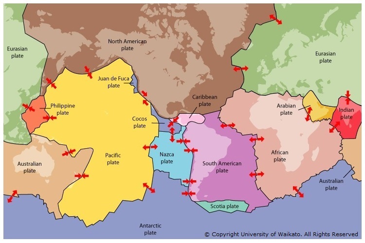
Where are the tectonic plates?
The major plates are the Antarctic, African, Eurasian, Australian, Pacific, North American, South American and Nazca. There are also a number of minor plates, such as the Indian, Arabian, Caribbean and Philippine. Some plates (such as the Pacific plate) have only oceanic crust, which is thinner and generally lies below sea level – others have both oceanic and continental crust that projects above sea level.
These plate boundaries are associated with geological events such as earthquakes and the creation of mountains, volcanoes and oceanic trenches. Most of the world’s active volcanoes occur along plate boundaries – the Pacific plate’s Ring of Fire is the most active.
New Zealand is right on the edges of two tectonic plates – the Australian and Pacific – and we get plenty of the action that goes with it!

Three types of plate boundaries
The plate boundaries are characterised by the way the plates move, and they are associated with different types of surface phenomena.
- Transform boundaries – The plates move past each other, but because of friction, they cannot just glide past each other so build up stress, which is released as an earthquake. New Zealand’s Alpine Fault is an example of this type.
- Divergent boundaries – The plates slide apart from each other, and the space that this creates is filled with new crust from the magma formed below in the asthenosphere. These boundaries can create great fracture zones that are a major source of submarine earthquakes.
- Convergent boundaries – The plates slide towards each other. When one plate moves underneath the other, it is known as a subduction zone, associated with deep marine trenches and volcanoes – some of the most explosive on Earth.
Where two continental plates collide they either buckle and compress, or one plate will go under or override the other, creating extensive mountain ranges. When two plates with oceanic crust collide, they usually create an island as one plate is descending (subducting) beneath the other.

Plate boundaries
There are three types of plate boundaries. They are each associated with different types of surface phenomena and are characterised by the way the plates move relative to each other. The different types are transform boundaries (which occur where plates slide past each other), divergent boundaries (which occur where two plates slide apart from each other) and convergent boundaries (where plates slide towards each other).
Related content
Find out more about Faults – a fracture in the Earth’s crust where the rock mass on either side has been displaced.
For younger students, see the resources mentioned in the On shaky ground article.
Activity ideas
Earthquakes New Zealand inroduces a series of activities designed to help students develop an understanding about earthquakes in New Zealand, including why we get them and how we measure them.
Check out our Earthquakes Pinterest board, it's full of ideas for additional resources.
Useful links
The purpose of GNS Science is to undertake research that enhances our understanding of geological and Earth system processes and increases Aotearoa New Zealand’s resilience to natural hazards and climate change.
The GeoNet website provides public access to hazards information, including earthquake reports and Volcanic Activity Bulletins. You can also report earthquakes you've felt here.
See the Natural Hazards Commission Toka Tū Ake website (previously the Earthquake Commission (EQC). It's aim is to reduce the impact on people and property when natural disasters occur, by protecting homeowners and helping them recover from natural hazard events.
In these Radio NZ Our Changing World programmes from 2022 explore the research of scientists Digging into the past of sleeping giant faults and Finding faults and eavesdropping on earthquakes in Aotearoa New Zealand.
