Discover information and hands-on activities about river catchments. Click on the labels for more information.
Select here to view the full transcript and copyright information.

Find out more about river catchments – both large and small – and where we fit with our local water catchments. Select a label for background information and hands-on activities.
To use this interactive, move your mouse or finger over any of the labelled boxes and click to obtain more information
Background map, Waikato Regional Council.
Transcript
Water flows and catchments
A water catchment is an area of land and the water that collects and moves through it. Catchments can be really big – like the Waikato River catchment – or very small – like a small wetland on someone’s property.
Use the following resources to learn about catchments.
Related articles
- Water catchments
- Waikato River ecology and biodiversity
- Planning for change
- Te whakamāherehere i ngā panonitanga
Related videos
This Rivers and Us resource is in a downloadable PDF format.
Select here to view the video transcript and copyright information.
Acknowledgement: The University of Waikato Te Whare Wānanga o Waikato and Waikato Regional Council
Mapping water at my school
The activity Mapping water at my school encourages students to actively observe what happens to precipitation in their local school catchment – the outdoor sports fields, courts, paths, playgrounds and roofs – and to identify the source of indoor water use and its disposal.
It uses online mapping and outdoor exploration to gather, interpret and critique data about the local environment.
The student handout has word cards students can use to create a water cycle that includes the water at their school.
Acknowledgement: Sergey Minaev, 123RF Ltd
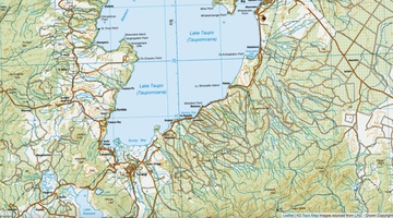
Mapping my local water catchment
The activity Mapping my local water catchment asks students to use an online topographic map to view their local catchment area(s) and consider how elevation, vegetation, land use and human activities influence waterways. It provides practice with the science capability ‘Interpret representations’.
These Rivers and Us resources are in a downloadable PDF format. Use them to learn about drinking water and wastewater treatment.
Acknowledgement: NZ Topo Map
Images sourced from LINZ – Crown Copyright
Build a model water catchment
The activity Building a model water catchment provides students with a three-dimensional experience of water catchments. Students can build a large outdoor model or smaller catchments using tote trays.
The activity provides a useful context in which to discuss models in science – why scientists use them, the similarities and differences between the model and a real catchment and the benefits and drawbacks of using a model.
Acknowledgement: Rivers and Us, Waikato Regional Council
Waikato River catchment
The Waikato River is significant for its enormous catchment area and for its importance to Waikato-Tainui, the mana whenua.
The following articles provide information about the Waikato River as an ecosystem, the significance of the river to its people and efforts to restore te mana o te awa.
- The Waikato River
- Waikato River ecology and biodiversity
- River ecosystems
- Human impacts on the Waikato River
- Raupatu (confiscation) and the Waikato River Settlement
- Te mana o te awa
- Kaitiakitanga and mana whakahaere
- Tikanga
- Whakataukī
- Waiata
- History of the Waikato River – timeline
Acknowledgement: Waikato-Tainui College for Research and Development
Acknowledgement
This interactive has been developed in partnership with the Waikato Regional Council as part of the Rivers and Us resource.