We rely on the natural world for recreation, building social connections and supporting our mental and spiritual health.
Our land 2024 is an environmental report produced by the Ministry for the Environment and Stats NZ. One of its key themes is that, when we look after nature, we are looking after ourselves. The report uses the term ‘natural infrastructure’ to describe elements of ecosystems and landscapes that are important to delivering benefits for the environment and human wellbeing.
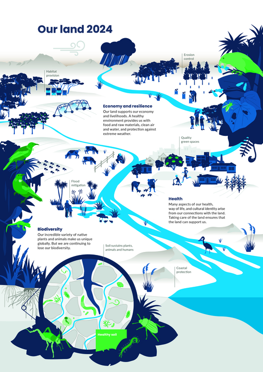
Our land 2024 – infographic
This infographic highlights key messages in Our land 2024 – how healthy ecosystems support the land and people in many ways.
Download a PDF of this infographic.
Source: Ministry for the Environment, Stats NZ and data providers and licensed by the Ministry for the Environment and Stats NZ for reuse under the Creative Commons Attribution 4.0 International licence.
Urban greenspaces as natural infrastructure
The report includes a case study about Te Auaunga to highlight the benefits that urban spaces can provide for our physical and social wellbeing.
Te Auaunga, known as ‘swirling waters’ or Oakley Creek, stands as the longest urban river, or awa, in the Auckland isthmus. It winds its way approximately 15 km from the high ridgeline above Waikōwhai to the Waitematā Harbour. Two hundred years ago, the awa was nestled within a vibrant wetland named Te Wai-inu-roa o Rakataura, meaning ‘the long drink of Rakataura’. This wetland served as a habitat for taonga like native birds, fish and plants used in rongoā while Māori harvested abundant harakeke and raupō for textiles. Papakāinga were sustained by the abundance of resources. Te Wai-inu-roa o Rakataura also played a crucial role in flood mitigation and drainage.
Land-use changes and grey infrastructure
From the 1840s, settlers drained the wetland and cleared the forests, transforming the area into farmland and later residential space. In the 1930s, flood mitigation led to the straightening and deepening of Te Auaunga. By the mid-1950s, Te Auaunga was confined within concrete pipes and channels to prevent flood damage to houses built on the natural floodplain.
The continued development of housing through the 20th and early 21st centuries increased the amount of impermeable surfaces, causing increased water flows and erosion in the lower catchment. The mauri of Te Auaunga stream had been much reduced; in its degraded state, it was unable to support the rich ecosystems of the wetland.
Rehabilitation and restoration
Healthy Waters Auckland and six iwi authority groups led the flood management and restoration project for Te Auaunga, which began in 2015–2016 with extensive local engagement. The project prioritised a range of social, cultural and ecological outcomes alongside flood risk reduction.
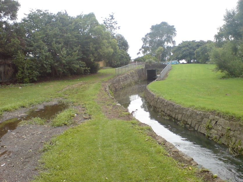
Before restoration, flooding in the area was managed with a fast-flowing culvert. This frequently failed to safeguard nearby houses, which continued to endure damage following heavy rainfall events. The concrete flood management system was not only inadequate, but it was also unlikely to handle projected increases in stormwater volume caused by climate change.
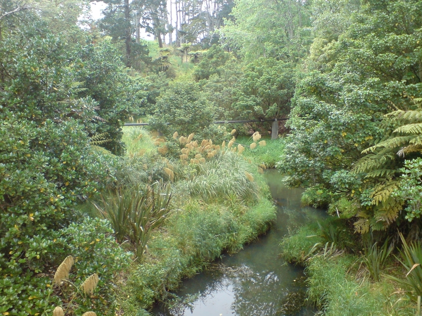
Transforming the concrete infrastructure into a more natural stream and wetland involved removing basalt, realigning the stream and replacing road culverts with bridges. Te Auaunga was widened to increase water-carrying capacity, thereby improving flood management for the surrounding area. Thousands of native plants provide natural water filtration and reduce pressure on downstream stormwater managements systems by enabling more water to be absorbed. Community engagement led to the inclusion of cycle paths, walking trails and recreational spaces with the result that more people used the park and they reported that the stream appears healthier.
Green infrastructure projects like Te Auaunga can also have economic benefits. While sometimes having high upfront costs, they can be more cost effective over time compared with grey infrastructure. The restoration of Te Auaunga employed 30 young people to construct and maintain the new infrastructure. It costs less to insure green than grey infrastructure and costs associated with damage from flooding are lower.
Years of collaborative efforts on the project have united community groups, fostering a shared sense of identity linked to Te Auaunga and the revitalised parkway. After Cyclone Gabrielle, efforts from community groups and extra volunteers quickly helped clear debris and restore the area, showing their connection with Te Auaunga. This unity is further represented by an artwork named Te Tohu o Te Auaunga, which can be seen along the stream. In its restored state, Te Auaunga is again able serve as natural infrastructure through improved flood management and water filtration as well as providing an urban green space for the residents.

Te Tohu o Te Auaunga
“This tohu represents the relationship of mana whenua to te awa. The tohu integrates mātauranga Māori and environmentally sustainable practices to restore the mauri of Te Auaunga so that it becomes a thriving flowing creek in a green corridor that is treasured and respected for generations to come.” – Whaotapu
Mana whenua have been involved as partners in Te Tohu o Te Auaunga. Mana whenua groups involved to date include Te Ākitai Waiohua, Ngāti Whātua Ōrākei, Ngāi Tai ki Tāmaki, Te Kawerau ā Maki, Te Ara Rangatahi o Te Iwi o Ngāti Te Ata Waiohua, Ngāti Tamaoho, Ngaati Whanaunga and Ngāti Te Ata Waiohua.
Tohu concepts and drawings by Whaotapu Trust: Sunnah Thompson and Wikuki Kingi. Digital rendering and design by River: Marcus Tsang, Rainui Teihotua and Isaac Rolfe.
For a full understanding of the motifs used within this design, refer to page 13 of Te Tohu o Te Auaunga Design Guide.
Nature of science
Reports like Our land 2024 rely heavily on data from Crown research institutes and central and local government. Environmental reports also contain social elements. Restoration projects often produce benefits that are not easily quantified in scientific or economic terms.
Related content
Oruarangi Stream shares a similar story with Te Auaunga. Read how the local community is working to restore its mauri.
Find out how artificial structures like culverts disrupt species migration.
Related activity
Te mana o te wai explores the concept of mauri – the health and wellbeing of a waterway.
Useful link
Stats NZ and the Ministry for the Environment report on different aspects of Aotearoa New Zealand’s environment every 6 months. Access their reports here.
Read a report on the project: Te Auaunga Awa (Oakley Creek) park and stream restoration project: an impact evaluation.
Acknowledgement
This resource has been produced with the support of the Ministry for the Environment and Stats NZ. © Crown copyright.

Our land 2024
The Ministry for the Environment and Stats NZ produce New Zealand’s Environmental Reporting Series. Our land 2024 describes how the ways we use the land have wide-ranging effects on our diverse ecosystems and the biodiversity they support, with cascading impacts on our economy, our resilience to disasters and our cultural, mental and physical health.
