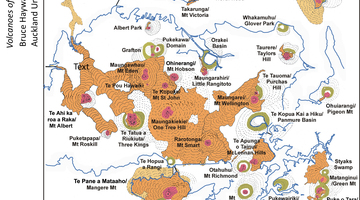
The Auckland Volcanic Field covers around 360 square kilometres under Auckland city. It includes 49 separate volcanoes, each of which is considered extinct. However the field as a whole remains active. Find out about some of these volcanoes in this interactive map.

This interactive only covers the Auckland Volcanic Field, to find out more about the major volcanoes in New Zealand go to this interactive.
To use this interactive, move your mouse or finger over any of the labelled boxes and select to obtain more information.
Transcript
Pukekawa (Auckland Domain)
Scoria cone volcano. Formed around 150,000 years ago. One of the first volcanoes formed in the Auckland volcanic field. Now a part of the Auckland Domain.
Acknowledgement: Google Earth
Pupuke Moana (Lake Pupuke)
Pupuke Moana (Lake Pupuke) on the North Shore of Auckland is a good example of a maar. It is the crater of a scoria cone volcano that last erupted around 140,000 years ago. The lava from explosions at Lake Pupuke trapped many trees, which have become fossilised. These are still visible at Takapuna beach.
Acknowledgement: Google Earth
Ōwairaka or Te Ahi-kā-a-Rakataura (Mt Albert)
A scoria cone volcano formed around 60,000 years ago that is 135 m in height. Now a busy suburb of Auckland.
Acknowledgement: Public domain
Ngā Kaoua Kohora (Crater Hill)
A scoria cone volcano formed around 30,000 years ago. Formed by a phreatomagmatic eruption where the lava interacts with water when it erupts. Similar eruption to the formation of Lake Pupuke.
Acknowledgement: Google Earth
Rarotonga (Mt Smart)
A scoria cone volcano formed around 20,000 years ago. Was originally around 80 m high but has been extensively quarried over the past 100 years for basalt and scoria. Now home to Mt Smart Stadium.
Acknowledgement: Public domain
Te Pane-o-Mataoho (Mt Māngere)
A scoria cone volcano formed around 18,000 years ago. Historically used as a Māori pā site (as were many volcanoes). Features a lava dome in the centre of the crater – the only Auckland volcano with this feature.
Acknowledgement: GeoNet
Maungakiekie (One Tree Hill)
A scoria cone volcano, which last erupted around 17,000 years ago. One of the largest eruptions in Auckland, the magma field ran through to Manukau Harbour. Historically, one of the largest pā sites in New Zealand.
Acknowledgement: Public domain
Te Tātua-a-Riukiuta (Three Kings)
Once four individual scoria cone volcanoes, these have been extensively quarried so only one peak remains. Last eruption was around 17,000 years ago. The area contains many lava tunnels formed by lava flows beneath the surface.
Acknowledgement: Public domain
Maungawhau (Mt Eden)
Mt Eden is a volcano that last erupted around 16,000 years ago. At 196 m in height, Mt Eden is the highest natural point in Auckland. Historically used as a pā site and also a quarry.
Acknowledgement: Lloyd Homer, GNS Science
Maungarei (Mt Wellington)
A scoria cone volcano that last erupted around 12,000 years ago. Mt Wellington is one of Auckland’s largest volcanoes (with One Tree Hill and Rangitoto). Quarried for industrial stone, it is now being developed for housing.
Acknowledgement: Public domain
Nga Rangi-i-totongia a Tamatekapua (Rangitoto Island)
Rangitoto is a small shield volcano with small scoria cones on top. It is the site of the most recent of Auckland’s volcanic eruptions, around 600 years ago, when Māori already inhabited the area. It is also the largest of the Auckland eruptions, equalling the volume of all previous eruptions combined.
Acknowledgement: Avenue, Creative Commons 2.5
Te Kopua-o-Matakerepo (Onepoto Basin)
Formed by a phreatomagmatic eruption similar to Lake Pupuke and Crater Hill. The crater was eroded over time and then drained to form a local park and playing fields. Last erupted around 20,000 years ago.
Acknowledgement: Google Earth


